
In the rapidly evolving world of digital design and construction, professionals increasingly rely on advanced tools to bridge the gap between physical reality and virtual modeling. Among these, Autodesk ReCap stands out as a powerful solution for transforming real-world data into actionable 3D intelligence. This sophisticated software empowers architects, engineers, and designers to capture, process, and utilize point cloud data with unprecedented precision and efficiency.

Understanding Autodesk ReCap: A Comprehensive Overview
Autodesk ReCap, short for Reality Capture, represents a cornerstone technology developed in the United States by Autodesk, a global leader in design software. It specializes in processing vast collections of points—known as point clouds—generated through laser scanning or photogrammetry techniques.
At its core, the software interprets data captured by emitting laser beams that measure distances to surfaces, creating millions of discrete points that collectively form a highly accurate digital replica of physical environments, objects, or structures. Each scan produces an immense dataset, where every point carries precise spatial coordinates, often accompanied by color and intensity information.
This capability has made Autodesk ReCap indispensable in industries requiring exact representations of existing conditions. From renovating historic buildings to planning large-scale infrastructure projects, the tool enables professionals to work with real-world geometry rather than starting from blank canvases, significantly reducing errors and improving project outcomes.
Over the years, adoption has grown exponentially among architecture, engineering, and construction (AEC) professionals, as well as in surveying, manufacturing, and heritage preservation sectors. The software’s evolution continues to incorporate cloud-based processing, artificial intelligence for automated cleanup, and enhanced visualization options.
Key Features That Define Autodesk ReCap Excellence
Beyond basic point cloud handling, Autodesk ReCap delivers a suite of advanced functionalities designed to streamline workflows and maximize data utility. These features transform raw scans into clean, intelligent models ready for downstream design and analysis.
Data Compression and Advanced Processing
One of the most critical challenges in reality capture is managing enormous file sizes. Autodesk ReCap excels here with proprietary compression algorithms that reduce storage requirements while preserving fidelity. It intelligently processes inputs from diverse scanning devices—terrestrial, aerial, or handheld—producing unified, high-resolution 3D models that retain intricate details essential for professional use.
Post-Processing and Cleanup Tools
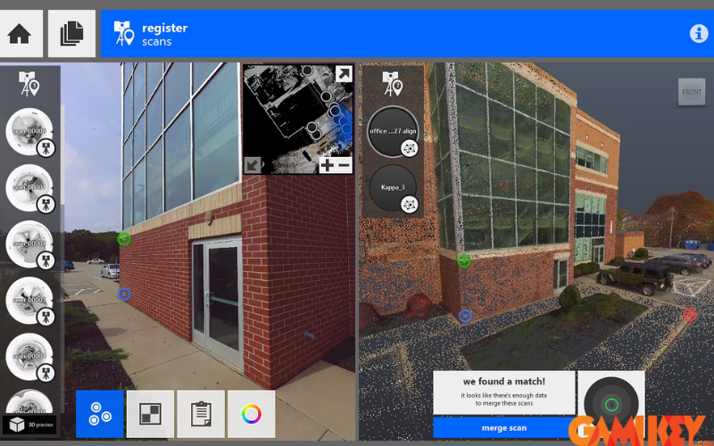
Real-world scans often include noise, unwanted background elements, or misalignments. Autodesk ReCap provides robust editing capabilities, including automated and manual tools for removing extraneous points, aligning multiple scans (registration), filling gaps, and reconstructing surfaces. Advanced region-based selection and machine-learning-assisted cleanup dramatically accelerate preparation time.
Seamless Integration Across Autodesk Ecosystem
Perhaps the greatest strength lies in its native compatibility with flagship Autodesk products. Point clouds processed in Autodesk ReCap import directly into Revit for BIM authoring, AutoCAD for 2D drafting, Civil 3D for infrastructure design, and Inventor for mechanical engineering. This interoperability ensures lossless data transfer and contextual intelligence throughout the project lifecycle.
3D Model Generation and Visualization
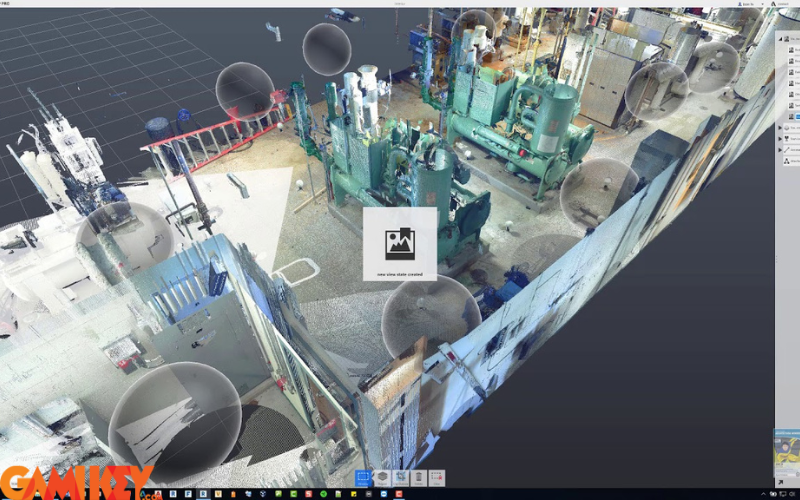
Users can generate mesh models, orthographic images, and annotated views directly within the platform. The software supports creation of fly-through animations, measurement tools, and section planes, enabling stakeholders to explore captured reality in immersive ways long before physical changes occur.
Analytics and Reporting Capabilities
Modern versions include measurement verification, volume calculations, deviation analysis, and custom reporting. These tools help quantify construction progress, identify clashes between as-built and as-designed conditions, or document heritage features with metrological accuracy.
Industry Applications of Autodesk ReCap
The versatility of Autodesk ReCap extends across multiple disciplines, delivering tangible value through improved accuracy, reduced rework, and enhanced decision-making.
Architecture, Engineering, and Construction (AEC)
In building design and renovation, scanned point clouds provide the foundation for accurate as-built documentation. Architects use them to model existing structures precisely, ensuring new interventions fit perfectly. Engineers perform structural assessments, clash detection, and quantity takeoffs with confidence derived from real measurements.
Facility and Project Management
Throughout construction and operations, periodic scans track progress against schedules. Facility managers monitor deformation, plan maintenance, or reconfigure spaces using up-to-date digital twins. The software supports 4D scheduling integration when combined with Navisworks or BIM 360.
Heritage Conservation and Documentation
Cultural institutions employ Autodesk ReCap to create permanent digital archives of monuments, artifacts, and archaeological sites. High-resolution 3D records preserve details threatened by time, climate, or conflict, enabling virtual tourism, restoration planning, and scholarly research.
Energy Efficiency and Building Performance
Energy auditors scan envelopes to identify thermal bridges, air leaks, or insulation deficiencies. The resulting models inform retrofit strategies that optimize HVAC sizing, daylighting, and overall sustainability metrics.
Geospatial and Infrastructure Projects
Civil engineers integrate point clouds with GIS datasets for topographic mapping, roadway design, and utility coordination. Large-scale scans of bridges, tunnels, or rail corridors support condition assessments and deformation monitoring over time.
Media, Marketing, and Product Visualization
Beyond traditional engineering, creative agencies leverage realistic 3D environments for virtual production, augmented reality experiences, or photorealistic renderings in advertising campaigns.
Integration Capabilities Within the Autodesk Portfolio
Autodesk ReCap functions as a vital link in Autodesk’s interconnected ecosystem. Processed point clouds become native elements in Revit families, AutoCAD drawings, InfraWorks simulations, and 3ds Max visualizations. This unified workflow eliminates format conversion losses and maintains parametric relationships.
Recent enhancements include direct publishing to Autodesk Construction Cloud, enabling collaborative review and markup across distributed teams. Mobile apps further extend accessibility, allowing field verification against scanned reality on tablets or smartphones.
To unlock the full potential of Autodesk ReCap and complementary tools, professionals typically subscribe to Autodesk’s comprehensive suites. These provide access to continual updates, cloud credits for intensive processing, and specialized extensions tailored to specific disciplines.
In summary, Autodesk ReCap transforms the way industries capture and leverage physical reality in digital workflows. Its combination of powerful processing, intelligent cleanup, seamless integration, and broad applicability continues to drive innovation across design, construction, preservation, and beyond—making it an essential asset for forward-thinking organizations worldwide.